Henry Fitch's guide to the Fitch Reservation

The 590-acre Fitch Natural History Reservation is a protected natural area that is one of several tracts of land that make up the KU Field Station, which is used extensively for environmental research and education and is administered by the Kansas Biological Survey & Center for Ecological Research at the University of Kansas. Please do not collect or disturb any plants, animals or research sites. To help protect the wildlife and natural character of this area for all users, please tread lightly and bring no pets.
The text below was developed and written by Henry Fitch in about 2000 for a guide to the Henry S. Fitch Nature Trail at the KU Field Station. It is based on his research and experience living at the reservation that now bears his name. The image above is included courtesy of the Fitch family. While the more remote upper trail is not regularly maintained and the 12 station markers are not all visible, the text here provides valuable information about the area's natural history. An electronic version of this guide in trifold format is available; please email biosurvey@ku.edu to request a copy.
The guide's introduction reads: This public trail is named in honor of Henry S. Fitch, professor emeritus at the University of Kansas. Fitch lived and worked on the reservation from shortly after it was dedicated in 1948 until 2009. He published more than 75 scholarly works that pertain to virtually every aspect of the natural history of this reservation. He, along with others at KU, have trained and educated thousands of students of all ages, with the reservation serving as an outdoor laboratory. Hike the Fitch Nature Trail, enjoy the outdoors and continue the legacy of learning about the natural environment that was established here by Prof. Fitch.
Fitch's text, along with the diagram of the trail, follows.
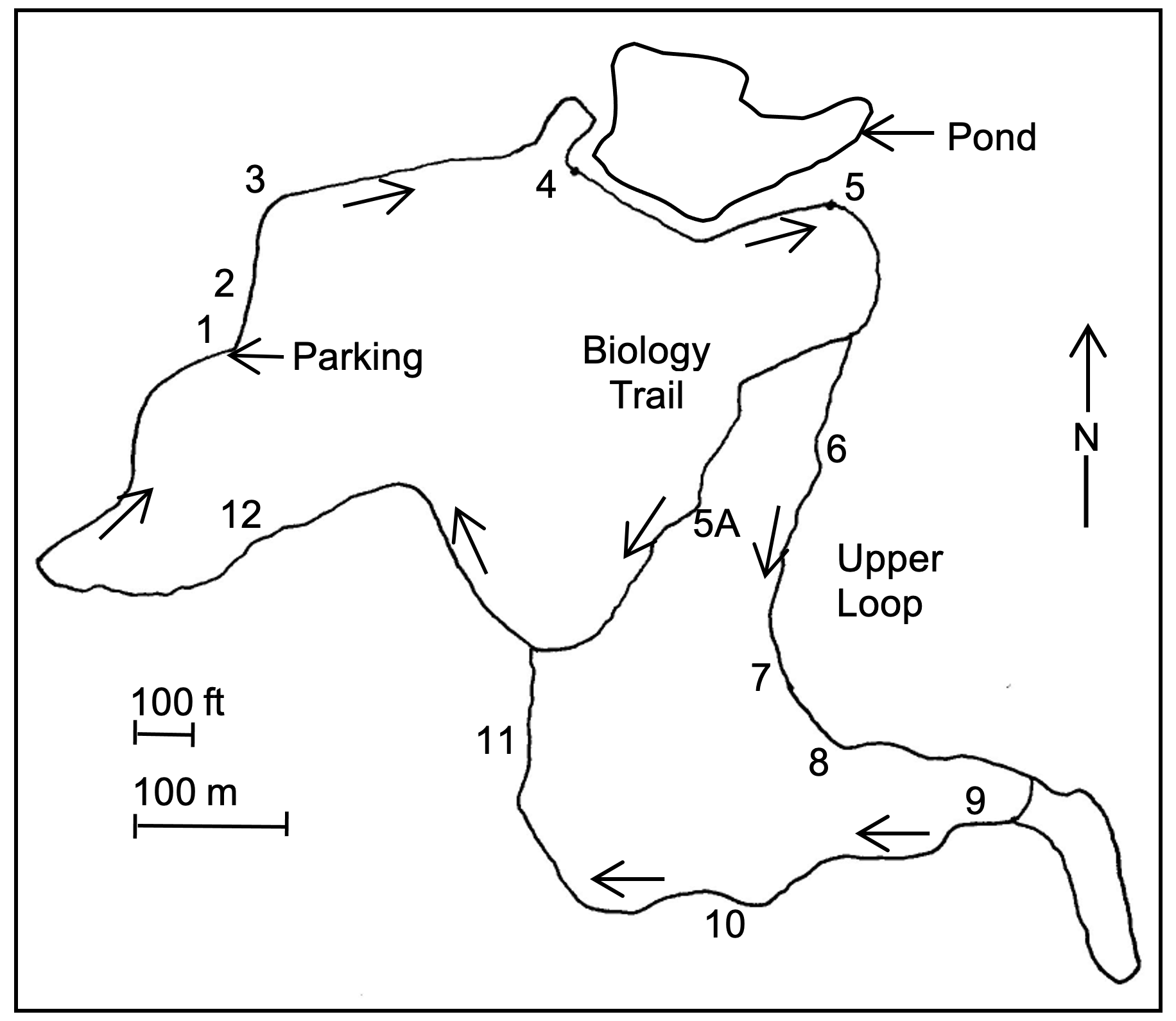
This nature trail consists of two loops. The longer loop is approx. 1.3 miles (2.1 km) in length and the shorter ("Biology Trail") loop is approx. 0.8 miles (1.3 km) in length. There are 13 marked "points of interest" along the way which describe various ecological and historical features. In addition, there are numerous plants (primarily trees) that are labeled with common and scientific names. The elevation at the parking lot is about 924 feet. The lower "Biology Trail" loop climbs to 998 feet, while the upper loop crosses the ridge top at 1060 feet near station #10. Both loops descend to their lowest point at an elevation of 902 feet at the creek crossing just before returning to the parking lot.
STATION 1 This whole area was formerly open grassland maintained by natural fires that killed invading woody plants but left the fire-resistant tallgrass prairie species. By 1948, when the area was made a reservation and protected as a natural area, previous heavy livestock grazing had altered the prairie. The introduced European grasses such as brome grass (Bromus inermis) and Kentucky bluegrass (Poa annua) and many other weedy forbs largely replaced the native prairie plants. In 1948, there were a few trees including the large Osage orange (Maclura pomifera) along the lane to the southwest and the honey locust (Gleditsia triacanthos) just west of the parking lot. Also, there were American elms (Ulmus americana), which have long since died from phloem necrosis as a result of contracting Dutch Elm disease. The open area (septic field) across the lane to the south is mowed regularly and as a result is still dominated by the introduced brome grass with woody vegetation largely absent.
STATION 2 This area has sparse vegetation because it was stripped of sod more than 60 years ago. At that time it had a thick stand of blue-grass and sod was taken to make lawns on campus. The most prominent plants on this impoverished soil area are red cedar (Juniperus virginiana), common blackberry (Rubus allegheniense), and broomsedge bluestem (Andropogon virginicus) none of which are growing on the area that was not stripped, just 30 feet east of this marker.
STATION 3 On this south-facing slope the microclimate is relatively hot and dry. Early in this century this was open prairie according to the testimony given by long-time residents that were questioned when the Reservation was first established. Trees have invaded since the area has been protected from fire and grazing. This scrubby woodland consists of early seral trees such as Osage orange and honey consists of early seral trees such as Osage orange and honey locust. There are no mature individuals of climax species such as oaks and hickories, but within 30 feet of this marker there are many seedlings and saplings of chestnut oak (Quercus muehlenbergii) and some of black oak (Q. velutina). The presence of these trees is beginning to change the aspect of the plant community, as ecological succession proceeds.
STATION 4 This pond was built in the early 1940s at the confluence of two ravines with intermittent watercourses. By 1948 heavy erosion in nearby cultivated upland fields had nearly filled the pond with silt and it became dry every year in late summer. In 1951 it was dredged to a depth of ten feet, the dam was built higher, and an outlet tube was installed. Since then, there has been permanent water and an aquatic fauna has developed including fish (red shiner (Cyprinella lutrensis), bullfrogs (Rana catesbeiana) and other frogs and toads of several species, snapping turtles (Chelydra serpentina), and water snakes. Non-resident ducks, herons, and Belted Kingfishers (Ceryle alcyon) stop here frequently. Beaver (Castor canadensis) and muskrat (Ondatra zibethicus) move in from time to time, but the habitat is too limited to support them permanently. Note the signs of beaver activity including bank burrows, excavated trenches leading to them, stumps left from cutting of small trees, and logs and sticks, stripped of bark, piled around den entrances.
STATION 5 This north slope has mixed woodland with some tree species of the forest climax— shagbark hickory (Carya ovata), chestnut oak, and black oak along with seral species such as honey locust and Osage orange that ordinarily grow in more open situations. These seral species are being shaded out and cannot reproduce in the shade under a dense leaf canopy. Their presence here indicates that conditions were formerly much more open. Some of the animals typical of this woodland are gray squirrel (Sciurus carolinenis), white-footed mouse (Peromyscus leucopus), Elliot's short-tail shrew (Blarina hylophaga), Red-bellied Woodpecker (Melanerpes carolinus), Tufted Titmouse (Parus bicolor), Black-capped Chickadee (Parus atricapillus), Red-eyed Vireo (Vireo olivaceus; in summer), black rat snake (Elaphe obsoleta), and eastern American toad (Bufo americanus).
STATION 5A This lower loop of the Fitch Trail follows the old "Biology Trail," which was used as a traditional field trip hike for all students enrolled in the beginning biology class at KU in the 1950s. This terrace-like hillside formation parallels the hilltop and follows along below the Oread limestone. This limestone formation originated from marine sediments laid down over millions of years during the Pennsylvanian geologic era more than 300 million years ago, when Kansas was covered by an inland sea. The direction of slope exposure affects the availability of sunlight and moisture that in turn determines which kinds of trees and other plants (as well as which animals) will live at any specific site.
STATION 6 This Oread Limestone was deposited here more than 300 million years ago, when Kansas was covered by an inland sea during the latter stages of the Pennsylvanian geologic era. Its deposition extended over millions of years, with many layers of varying thickness and hardness. Here at the hilltop, near the 1040-foot contour, we see the Plattsmouth member of the formation. Twenty feet lower on the slope is another hard layer, darker than the Plattsmouth and brownish in color. This layer is the Toronto member. At the time of deposition the animal life underwent marked changes from layer to layer as evolution progressed and the sea depth changed. The Plattsmouth member has abundant invertebrate fossils. Especially prominent are fusilinids (protozoans having calcareous tests or shells) almost as large as a wheat grain; sea "lilies" (actually animals of the phylum Echinodermata) that attached to the substrate by segmented stalks about 1/4 inch in diameter; and brachipods (primitive invertebrates) having clam-like ribbed shells, of about thumbnail size, but with shells that are dorsal and ventral rather than left and right as in bivalve mollusks.
Under present conditions the Oread limestone is important to several kinds of animals. The eastern woodrat (Neotoma floridana) prefers to make its home along these outcrops by lining the fissures with sticks to create secure shelters, as can be readily seen here. Most of the 17 local snake species found on the Fitch Natural History Reservation leave their summer ranges in autumn and seek hibernacula in deep fissures in the Oread limestone, generally in areas with southern exposures.
STATION 7 This flat hilltop is the "cuesta" formation characteristic of northeastern Kansas. There is only a shallow layer of soil underlain by the Oread limestone. In the 1940s this hilltop was a cow pasture, virtually treeless with brome grass as the dominant vegetation. Since then, many kinds of trees and shrubs have invaded the area. Shrubs such as smooth sumac (Rhus glabra), roughleaf dogwood (Cornus drummondii), and American plum (Prunus americana) are typical of early invaders followed by honey locust, Osage orange, American elm, white ash (Fraxinus americana), redbud (Cercis canadensis), and black walnut (Juglans nigra). However, notice that the middle of the ridge to the south of this marker is still relatively open and devoid of even these early invading woody species and that climax trees such as oaks and hickories are almost totally absent.
STATION 8 This grove with mature trees and sparse undergrowth is dominated by black oak, as well as other climax forest species such as chestnut oak, bur oak (Quercus macrocarpa), and shagbark hickory. Also present are some seral trees such as honey locust, which suggests that there were more open conditions in times past. In northeastern Kansas we are at the western edge of the Deciduous Forest Biome that formerly covered the eastern United States. Of the four climax species occurring here, bur oak extends farthest west and is the common tree in the Flint Hills, with small groves in protected sites such as steep-sided ravines. Locally, in pre-European settlement times most forest was in the Kansas River floodplain, while the more extensive uplands were mainly tallgrass prairie.
STATION 9 This land was part of a former Delaware Indian reservation that extended from the Kansas River north to the Nebraska border. In the 1860s, after the Delaware were moved a second time from Kansas to the Oklahoma territory, Charles Robinson, the first governor of Kansas, acquired this section of land. Long known as the "Robinson pasture" the land was grazed and the cattle confined by stone walls before wire fencing came into general use. Limestone from on site was used to build the walls, which bisect the property from north to south and from east to west. These two walls cross approximately 60 feet east of this marker at the exact center of the section. Later wire fences replaced these walls and many of the limestone slabs were hauled to Lawrence for buildings, but in some places basal layers of the walls remain. Here a large bur oak grows on top of the tumbled down remains of the wall and 120 feet farther west is a chestnut oak in a similar situation. Although these trees cannot be older than the wall itself, they may be almost 135 years old. Remains of the wall provide shelter for various animals including white-footed mice, Elliot's short-tail shrews, and snakes and skinks. A new species of cellar spider Pholcus muralicola (Maughan & Fitch), found in large numbers beneath the basal slabs of this wall, was described from this locale, and has not been found anywhere else.
STATION 10 At a time when this hilltop was open pasture, this was the site of a saltlick. The concentrated activity of the cattle pulverized the soil and in dry weather dust blew off leaving a depression, in a process similar to the formation of buffalo wallows in earlier times, the remains of some of which still exist elsewhere at the Field Station. Residual salt still renders this spot attractive to whitetail deer (Odocoileus virginianus). Red cedar trees nearby have been partly girdled by one or more bucks using them to polish their antlers. The springy stems and branches of red cedar make them a favorite tree for such activity by bucks in the autumn.
STATION 11 During the past half century this wooded slope has changed little in appearance, in contrast to some other areas on the Reservation that are much altered by succession. However, American elm, which was formerly the dominant tree on this slope, has been largely replaced by other species. Elms were greatly reduced by a die-off that began in the 1950s from the introduction of Dutch Elm disease and its carrier the European elm bark beetle (Scolytus multistriatus).
Tree ring analysis performed in the 1950s at the base of this slope indicated that this stand of forest dates back at least several decades into the late 1800s, when Douglas County had much more tallgrass prairie and less woodland. The double or multiple trunks evident on many of the oaks and hickories on this site are a result of regenerated stump sprouts following tree-cutting in the first half of the twentieth century.
STATION 12 This intermittent stream is a tributary of Mud Creek, which in turn empties into the Kansas River. The streambed is a corridor for moisture-loving animals like the Blanchard's cricket frog (Acris crepitans), snapping turtle, and northern water snake (Nerodia sipedon) and their predator the raccoon (Procyon lotor). Sycamores (Platanus occidentalis) grow in this rocky ravine farther upstream. Plains cottonwoods (Populus deltoides ssp. monilifera) like this one and the giant specimen near the stream crossing farther downstream, establish themselves where there are silt deposits. There is evidence that since European settlement severe erosion has occurred, with down-cutting of the gully channel. In presettlement times the gully was much shallower and the aquatic habitat more extensive, with many small dams (made and maintained by beaver) and sloughs where now there are cultivated fields on the land west of the Reservation.